Laser Scanning Range
| Ht 5.5 | ||||||||||
|---|---|---|---|---|---|---|---|---|---|---|
| Distance | 50 | 100 | 150 | 200 | 250 | 300 | 350 | 400 | 450 | 500 |
| Delta Dist | 49.93 | 99.71 | 149.36 | 198.86 | 248.23 | 297.45 | 346.54 | 395.48 | 444.29 | 492.96 |
| GSD | 0.07 | 0.29 | 0.64 | 1.14 | 1.77 | 2.55 | 3.46 | 4.52 | 5.71 | 7.04 |
| Inc Ang | 83.72 | 86.85 | 87.90 | 88.42 | 88.74 | 88.95 | 89.10 | 89.21 | 89.30 | 89.37 |
And at 7.5 feet:
| Ht 7.5 | ||||||||||
|---|---|---|---|---|---|---|---|---|---|---|
| Distance | 50 | 100 | 150 | 200 | 250 | 300 | 350 | 400 | 450 | 500 |
| Delta Dist | 49.95 | 99.79 | 149.53 | 199.16 | 248.70 | 298.13 | 347.45 | 396.68 | 445.80 | 494.82 |
| GSD | 0.05 | 0.21 | 0.47 | 0.84 | 1.30 | 1.87 | 2.55 | 3.32 | 4.20 | 5.18 |
| Inc Ang | 81.47 | 85.71 | 87.14 | 87.85 | 88.28 | 88.57 | 88.77 | 88.93 | 89.05 | 89.14 |
And at 10.5 feet:
Not only does the angle of incidence approach 90 degrees giving less reliable results but the GSD (or the distance between samples in this case) becomes larger as well. In static scanning points nearer the instrument are generally much denser than those 100 feet from the scanner. Just how far away from the scanner is reasonable to scan before the sampling distance is insufficient in spacing and quality?
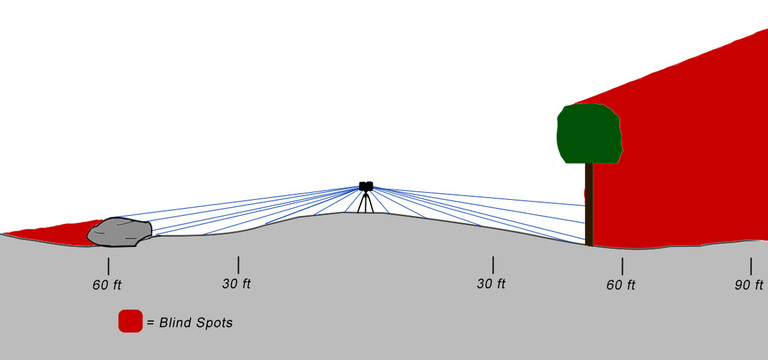
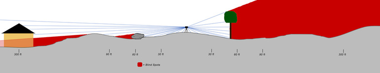
One more thing, line of sight in relation to the ground is even a bit trickier than for poles, buildings, etc. The ground undulates so as the distance increases from the scanner, dips and ditches, mounds and humps, etc., become much less likely to be included in the data resulting in shadowing, or voids. Hence,
One more thing, line of sight in relation to the ground is even a bit trickier than for poles, buildings, etc. The ground undulates so as the distance increases from the scanner, dips and ditches, mounds and humps, etc., become much less likely to be included in the data resulting in shadowing, or voids. Hence,
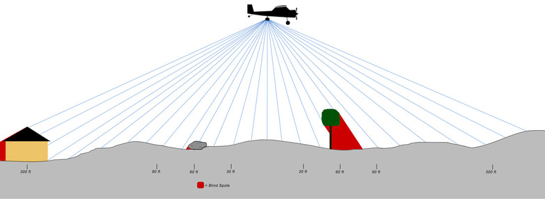
Range is important. This is absolutely true when scanning across rivers, tall structures, across open pits or mines, to areas that are otherwise inaccessible from the ground. The FARO X330 can scan to ranges greater than 330 meters, but for ranges exceeding much more than this either a longer range scanner is required or a UAV, helicopter, or gyroplane (maybe a boat) carrying Snoopy.
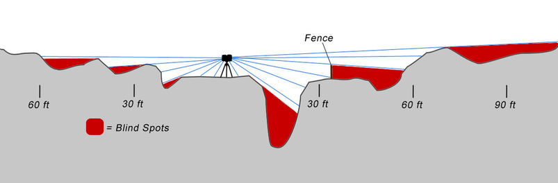
Mobile Scanning. How does all of this apply to mobile scanning? It is almost exactly the same. The angle of incidence, the lay of the land (ditches), the sampling distance and density, the reliability, instrument height – these all affect the actual, reliable scanning range. ScanLook using the F3D can provide the best scan data available on a mobile platform for near range, hard surface areas. This is primarily concerned with pavement, curb and gutter, engineering and surveying grade work. For assets and mapping grade data ScanLook employs the Velodyne HD32. Its range is effectively 70 to 80 meters and at several centimeters precision. In almost all of the scanning we have done we cannot realize this distance in scanning for a very simple reason – obstructions. Most roadways have buildings, fences, or greenery within 50 to 100 feet from the road. Because Snoopy is small and light, mounting high above the vehicle allows us to scan quite high to minimize shadowing in ditches, over fences, etc. In this case being a light system is important.
Mobile Scanning. How does all of this apply to mobile scanning? It is almost exactly the same. The angle of incidence, the lay of the land (ditches), the sampling distance and density, the reliability, instrument height – these all affect the actual, reliable scanning range. ScanLook using the F3D can provide the best scan data available on a mobile platform for near range, hard surface areas. This is primarily concerned with pavement, curb and gutter, engineering and surveying grade work. For assets and mapping grade data ScanLook employs the Velodyne HD32. Its range is effectively 70 to 80 meters and at several centimeters precision. In almost all of the scanning we have done we cannot realize this distance in scanning for a very simple reason – obstructions. Most roadways have buildings, fences, or greenery within 50 to 100 feet from the road. Because Snoopy is small and light, mounting high above the vehicle allows us to scan quite high to minimize shadowing in ditches, over fences, etc. In this case being a light system is important.